
Cover Story
By Dr David Menier
Since 1960, more than 50 earthquakes have occurred in and around Sabah according to United States Geological Survey (USGS) quake data. Average magnitude of earthquakes in the region is above 4.0 in the seismicity scale (also called Richter scale) with a maximum of 10.0.
Friday’s (June 5) earthquake, which struck an area close to Ranau, near the foot of the picturesque Mount Kinabalu, claimed the lives of more than 10 people including school children.
The number of aftershocks have continued with the worst tremor measuring 4.3 on the Richter scale being felt for the first time, in the heart of Kota Kinabalu on June 23. The number of tremors since the 5.9-magnitude earthquake has now hit 90.

The BIG question: Can Peninsular Malaysia be hit?
The Ranau quake was a result of a slip along active fault lines due to accumulated strain created by movement of continental plates. A series of faults occurring onshore Borneo and offshore are sensitive to continental plate motions. Northwest Borneo accumulates strain in the subsurface because of the northward movement of the Australian plate and the Philippines plate moving westward, geologists say.

Rejuvenation of Old Fault Lines
Research conducted by geologists David Menier and Manoj Mathew of Universiti Teknologi PETRONAS, uncovered indicators of vertical crustal movements during fieldwork in Sabah last year; 40km south of the epicentre of Friday’s quake.
The researchers discovered that these motions, controlled by active fault lines oriented Northeast-Southwest, created uplift of topography over the past 500,000 years and continues to date in the southern part of Ranau, from Keningau plain till Tenom plain. In an article submitted to a peer-reviewed journal, they had anticipated active surface movements as a result of rejuvenation of old fault lines on the basis of their analysis.
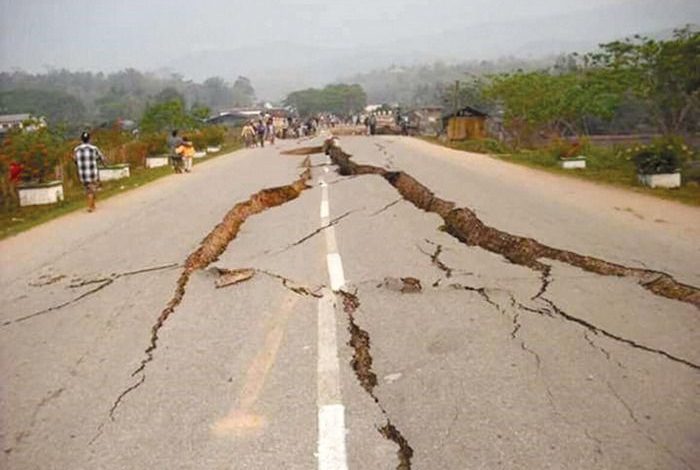
Earthquakes lead to the formation of fractures below the surface of the upper crust into which surface runoff water can penetrate and cause landslides. Monsoon rains wash soils down the hillsides and the risk of landslides due to slope instability by the Sabah quake is still a possibility that cannot be disregarded, according to them.
 Are there any recurrences expected and why?
Aftershocks can usually occur over the entire fault rupture zone for a few days after the main shock because strain can be transferred further along the displaced fault. Depending on the underlying structural configuration, strain from the main shock may disturb a number of neighbouring faults within the affected volume resulting in aftershocks.
Seismic waves
In the event of an earthquake, accumulated strain energy is released as seismic waves that travel through the layers of the earth and away from the epicentre. Generally, there are two major types of seismic waves. Firstly, the fastest type of waves called Body waves (P and S waves) which travel through the interior of the earth and are first to arrive at a seismic station. Secondly, surface waves which travel along the earth’s surface and are almost entirely responsible for the catastrophe associated with earthquakes.

Is there any relation between man-made activities to the quake?
Human activity that alter the stresses and strains on the earth’s crust may produce few minor tremors. According to a report by the United States Geological Survey, induced seismicity due to human activity are a relatively new phenomenon. Some man-made activities that may cause tremors include construction of artificial reservoirs and lakes, underground disposal of waste liquids from oil and gas wells and mineral industry through subsurface injection, extensive mining, among others. All these activities can increase the stress along an existing fault line causing it to reactivate.
With the available technology and data compiled, can we predict when the next earthquake may strike in Sabah and Mount Kinabalu?
Seismologists and geologists, over the years, have been working towards designing a reliable technique to predict earthquakes. The closest that scientists got to forecasting quakes are statistical estimations using data of past and present earthquakes which, unfortunately, do not provide precise predictions. Previously, the first recorded earthquake in Ranau area was in 1966 with magnitude 5.3 on the Richter scale, another one in 1991 measuring 5.2 and the most recent quake measuring 6.0. Statistically, these three quakes occurred in 25 year intervals between each. Geologists and geomorphologists can provide information regarding tectonically stable/unstable zones and evidences of active fault lines and their relative movements. Based on these information, fault maps can be prepared and potential geohazard sites may be delineated. However, predicting the exact location and timing of fault rupture and quake magnitude is a difficult task. Nonetheless, the accurate prediction of the recent Nepal quake by scientists offer a glimmer of hope for quake prediction research.

Will the next round of earthquakes become more severe, exceeding 6 on the Richter scale?
As mentioned in the previous reply, precisely determining position, timing and quake magnitude is challenging and complicated. Nevertheless, Sabah has experienced more than 50 earthquakes since 1960, and statistically, the average magnitude is 4.0 in the seismicity scale.
Is it true that other areas in the peninsula, that is, Kuala Lumpur, Bukit Tinggi (Pahang) and Manjung (Perak) are also exposed to earthquake, as reported in the media?
Compressional forces due to the northward movement of the Australian plate and the Philippines plate moving westward mainly affects parts of Borneo. Peninsular Malaysia is generally a sheltered zone and although it has experienced tremors in the past, these are minor vibrations following strong earthquakes in neighbouring Indonesia.
Rejuvenated fault lines – Is it normal and what are the main causes?
A fault is a break in the earth’s crust along which movement can take place resulting in an earthquake. Faults may be small and localised or can stretch thousands of miles. Faults are related to the movement of Earth’s tectonic plates. Rocks on either side of the fault move past each other at rates which are too slow for us to notice. Sometimes, due to friction, the fault holds the rocks together in such a way that they do not move past each other. Subsequently, stress builds up until the rocks slip, suddenly causing a quake. This phenomenon is termed fault reactivation or rejuvenation of older faults. Depending on the underlying structural configuration, strain from the quake may disturb a number of neighbouring faults within the affected volume resulting in aftershocks.
